View Interesting Maps in a larger map
Whitby Abbey is a ruined Benedictine abbey sited on the East Cliff, 199 steps above Whitby harbour in North Yorkshire on the north-east coast of England.
It was founded in 657 AD by the Anglo-Saxon King of Northumbria, Oswy (Oswiu) as Streoneshalh (the historical name of the town Whitby where the abbey is located).[1] He appointed Lady Hilda, abbess of Hartlepool Abbey and niece of Edwin the first Christian king of Northumbria, as founding Abbess. The name Streoneshalh is thought to signify Fort Bay or Tower Bay in reference to a supposed Roman settlement that previously existed on the site. This contention has never been proven though and alternate theories have been proposed, such as the name meaning Streona's settlement; a reference to Eadric Streona. This is highly unlikely though due to chronological considerations: Streona died in 1017 so the naming of Streoneshalh would have preceded his birth by several hundred years.[2]
The double monastery of Benedictine monks and nuns was also home to the great Saxon poet Caedmon. In 664, the abbey was the site of the Synod of Whitby, at which King Oswiu ruled that the Northumbrian Church would adopt the Roman calculation of Easter and monastic tonsure.
In 867, the abbey fell to Viking attack, and was abandoned.
William de Percy ordered that the abbey be refounded (1078) by Regenfrith (Reinferd) a soldier monk, dedicating it to St. Peter and St. Hilda. Later it became Presteby (meaning the habitation of Priests in Old Norse) then Hwytby; next Whiteby, (meaning the "white settlement" in Old Norse, probably from the colour of the houses) and finally Whitby.
The second monastery lasted until it was destroyed by Henry VIII in 1540 during the Dissolution of the Monasteries. The abbey buildings fell into ruins, and were mined for stone, but remained a prominent landmark for sailors and helped inspire Bram Stoker's Dracula.[citation needed] The ruins are now owned and maintained by English Heritage.
Source:
Whitby Abbey - Wikipedia
 The Semperoper is the opera house of the Saxon State Opera Dresden (German: Sächsische Staatsoper Dresden) and the concert hall of the Sächsische Staatskapelle Dresden in Dresden, Germany. It was first built in 1841, by architect Gottfried Semper.
 The Zwinger Palace (Der Dresdner Zwinger) in Dresden is a major baroque German landmark.
 The San Diego Museum of Man is a museum of anthropology located in Balboa Park, San Diego, California. The museum's collections and permanent exhibits focus on the pre-Columbian history of the western Americas, with materials drawn from Native American cultures of the Southern California region, Mesoamerican civilizations such as the Maya, and the Andean civilizations such as the Moche. The museum also holds a collection of Ancient Egyptian antiquities, and several others from around the world. Total holdings number over 72,000 artefacts across all collections, together with some 37,000 historical photographs, mainly of Native Americans.
 Isla de Janitzio is the main island of Lake Patzcuaro in the state of Michoacán, Mexico.
 Griffith Observatory is located in Los Angeles, California, United States. Sitting on the south-facing slope of Mount Hollywood in L.A.'s Griffith Park, it commands a view of the Los Angeles Basin, including downtown Los Angeles to the southeast, Hollywood to the south, and the Pacific Ocean to the southwest. The observatory is a popular tourist attraction that features an extensive array of space- and science-related displays.
 Detian - Banyue Falls (Chinese: 德天瀑布 & 板約瀑布) or Ban Gioc Falls (Vietnamese: thác Bản Giốc),[Note 1] are 2 waterfalls on the Quy Xuan River straddling the Sino-Vietnamese border, located in in the Karst hills of Daxing County in the Chongzuo prefecture of Guangxi Province, on the Chinese side, and in the district of Trung Khanh, Cao Bằng province on the Vietnamese side, 272 km north of Hanoi.[Ref 1]
 The Cathedral of Christ the Saviour (Russian: Храм Христа Спасителя) or Hram hrista spasitelya is a Church in Moscow, Russia, on the bank of the Moskva River, a few blocks west of the Kremlin. It is the tallest Eastern Orthodox church.
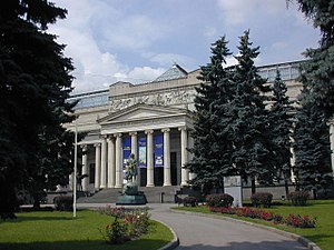 The Pushkin Museum of Fine Arts (Russian: Музей изобразительных искусств им. А.С. Пушкина) is the largest museum of European art in Moscow, located in Volkhonka street, just opposite the
  The USS Arizona Memorial, located at Pearl Harbor in the City and County of Honolulu, Hawaiʻi, marks the resting place of 1,102 of the 1,177 sailors killed on the USS Arizona during the Attack on Pearl Harbor on December 7, 1941 by Japanese imperial forces and commemorates the events of that day. The attack on Pearl Harbor and the island of Oʻahu was the action that led to United States involvement in World War II.
 Meteor Crater is a meteorite impact crater located approximately 43 miles (69 km) east of Flagstaff, near Winslow in the northern Arizona desert of the United States. Because the US Department of the Interior Division of Names commonly recognizes names of natural features derived from the nearest post office, the feature acquired the name of "Meteor Crater" from the nearby post office named Meteor[1]. The site was formerly known as the Canyon Diablo Crater, and scientists generally refer to it as Barringer Crater in honor of Daniel Barringer who was first to suggest that it was produced by meteorite impact. The crater is privately owned by the Barringer family via their Barringer Crater Company.[2]
 Crater Lake is a caldera lake located in the U.S. state of Oregon. It is the main feature of Crater Lake National Park and famous for its deep blue color and water clarity. The lake partly fills a nearly 1,958 foot (597 m) deep caldera[1] that was formed around 7,700 (± 150) BC[2] by the collapse of the volcano Mount Mazama.
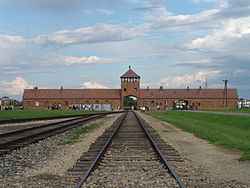 Auschwitz-Birkenau was the largest of Nazi Germany's concentration camps and extermination camps, operational during World War II.


