View Interesting Maps in a larger map
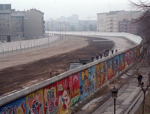 The Berlin Wall (German: Berliner Mauer) was erected by the German Democratic Republic (GDR) (East Germany) completely encircling West Berlin, separating it from East Germany, including East Berlin. The longer inner German border demarcated the border between East and West Germany. Both borders came to symbolize the Iron Curtain between Western Europe and the Eastern Bloc. Prior to the Wall's erection, 3.5 million East Germans had avoided Eastern Bloc emigration restrictions to escape into West Germany, many over the border between East and West Berlin. During its existence from 1961 to 1989, the Wall stopped almost all such emigration and separated East Germany from West Germany for more than a quarter of a century.[1] The Wall included guard towers lining large concrete walls circumscribing a wide area (later known as the "death strip") containing anti-vehicle trenches, "fakir beds" and other defenses. After its erection, around 5,000 people attempted to escape circumventing the wall, with estimates of the resulting death toll varying between 98 and 200.
During a revolutionary wave sweeping across the Eastern Bloc, the East German government announced on November 9, 1989, after several weeks of civil unrest, that all GDR citizens could visit West Germany and West Berlin. Crowds of East Germans climbed onto and crossed the wall, joined by West Germans on the other side in a celebratory atmosphere. Over the next few weeks, parts of the wall were chipped away by a euphoric public and by souvenir hunters; industrial equipment was later used to remove almost all of the rest. The fall of the Berlin Wall paved the way for German reunification, which was formally concluded on October 3, 1990.
Source: Berlin Wall - Wikipedia
 Rothenburg ob der Tauber is a town in the district of Ansbach of Mittelfranken (Middle Franconia), the Franconia region of Bavaria, Germany, well known for its well-preserved medieval old town, a destination for tourists from around the world. In the Middle Ages, it was an Imperial Free City. A significant fraction of Rothenburg is car-free.
 The Bamberg Cathedral (German: Bamberger Dom, official name Bamberger Dom St. Peter und St. Georg) is one of the best-known architectural monuments in Germany and has been Bamberg’s most famous landmark since its completion in the 13th century. The cathedral is under the administration of the Roman Catholic Church and is the seat of the Archbishop of Bamberg.
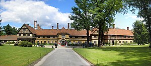 Schloss Cecilienhof is a palace in the northern part of the Neuer Garten park in Potsdam, close to the Jungfernsee lake. Since 1990 it is part of the Palaces and Parks of Potsdam and Berlin UNESCO World Heritage Site.
 Tübingen, a traditional university town in Baden-Württemberg, Germany, is situated 30 km (19 miles) southwest of Stuttgart, on a ridge between the Neckar and Ammer rivers.
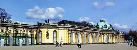 Sanssouci is the former summer palace of Frederick the Great, King of Prussia, in Potsdam, near Berlin. It is often counted among the German rivals of Versailles. While Sanssouci is in the more intimate Rococo style and is far smaller than its French Baroque counterpart, it too is notable for the numerous temples and follies in the park. The palace was designed by Georg Wenzeslaus von Knobelsdorff between 1745 and 1747 to fulfil King Frederick's need for a private residence where he could relax away from the pomp and ceremony of the Berlin court. This is emphasised by the palace's name: a French phrase (sans souci) which translates loosely as "without worries" or "carefree" symbolising that the palace was a place for relaxation rather than a seat of power. The palace is little more than a large single-storey villa—more like the Château de Marly than Versailles. Containing just ten principal rooms, it was built on the brow of a terraced hill at the centre of the park. The influence of King Frederick's personal taste in the design and decoration of the palace was so great that its style is characterised as "Frederician Rococo", and his feelings for the palace were so strong that he conceived it as "a place that would die with him".[1] Because of a disagreement about the site of the palace in the park, Knobelsdorff was fired in 1746. Jan Bouman, a Dutch architect, finished the project.
 Rovos Rail is a private railway company operating out of Capital Park Station in Pretoria, South Africa.
 The Dresdner Frauenkirche ("Church of Our Lady") is a Lutheran church in Dresden, Germany.


