Interesting spot on the maps, virtual sign seeing on the net.

Sunday, August 19, 2012

Mussenden Temple


View Interesting Maps in a larger map


Mussenden Temple is a small circular building located on cliffs near Castlerock in County Londonderry, high above the Atlantic Ocean on the north-western coast of Northern Ireland.

It was built in 1785 and forms part of the estate of Frederick Augustus Hervey, the 4th Earl of Bristol, Bishop of Derry. Built as a library and modelled from the Temple of Vesta in Italy, it is dedicated to the memory of Hervey's cousin Frideswide Mussenden. Over the years the erosion of the cliff face at Downhill has brought Mussenden Temple ever closer to the edge, and in 1997 the National Trust carried out cliff stabilisation work to prevent the loss of the building.

Wikipedia - Mussenden Temple

Wednesday, August 15, 2012

Cornbury Park


View Interesting Maps in a larger map

Cornbury Park was a former Royal estate used for hunting. It is located near, a few miles from Charlbury, near the Wychwood Forest in Oxfordshire. A two-story, eleven-bay 17th-century house stands in the grounds. The park is now the location for an annual music festuval.

Wikipedia - Cornbury Park

Sunday, July 22, 2012

Padirac Cave


View Interesting Maps in a larger map

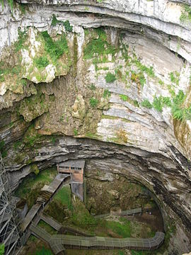
The Padirac Chasm or Gouffre de Padirac is a cave located near Gramat, in the Lot département, in France.

The chasm itself is approximately 99 m (325 ft) around its rim with a diameter of approximately 35 metres (115 ft). Visitors descend 75 m via a lift or a staircase before entering the cave system. The cave, at a depth of 103 metres (338 ft), contains a subterranean river system that is partly negotiable by boat. This cave system is regarded as "one of the most extraordinary natural phenomena of the Massif Central".

Wikipedia - Padirac Cave

Sunday, May 27, 2012

Golden Gate Bridge


View Interesting Maps in a larger map

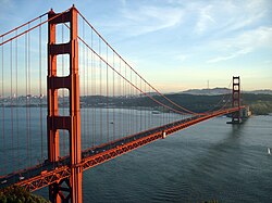
Golden Gate Bridge is a suspension bridge spanning the Golden Gate, the opening of the San Francisco Bay into the Pacific Ocean. As part of both U.S. Route 101 and California State Route 1, the structure links the city of San Francisco, on the northern tip of the San Francisco Peninsula, to Marin County. It is one of the most internationally recognized symbols of San Francisco, California, and the United States. It has been declared one of the modern Wonders of the World by the American Society of Civil Engineers. The Frommers travel guide considers the Golden Gate Bridge "possibly the most beautiful, certainly the most photographed, bridge in the world".

Wikipedia - Golden Gate Bridge

Wednesday, March 21, 2012

Königssee


View Interesting Maps in a larger map

Königssee
The Königssee is a lake located in the extreme southeast Berchtesgadener Land district of the German state of Bavaria, near the border with Austria. Large parts are comprised by the Berchtesgaden National Park.

Lying within the Berchtesgaden Alps in the municipality of Schönau am Königsee, just south of Berchtesgaden and the Austrian City of Salzburg, the Königssee is Germany's third deepest lake. Located at a Jurassic rift it was formed by glaciers during the last ice age. It stretches about 7.7 km (4.8 mi) in the north-south direction and is about 1.7 km (1.1 mi) across at its widest point. Except at its outlet, the Königsseer Ache at the village of Königssee, the lake similar to a fjord is surrounded by steeply rising flanks of mountains up to 2700 m (8900 ft), including the fabled Watzmann massif in the west.

The literal translation appears to be "King's Lake", however while German: König does indeed mean "king", there had been no Bavarian kings since the days of Louis the German until Elector Maximilian I Joseph assumed the royal title in 1806. Therefore the name more probably stems from the first name Kuno of local nobles, who appear in several historical sources referring to the donation of the Berchtesgaden Provostry in the 12th century; the lake was formerly called Kunigsee.

Wikipedia - Königssee

Sunday, March 11, 2012

Denali National Park and Preserve


View Interesting Maps in a larger map


Denali National Park and Preserve is located in Interior Alaska and contains Denali (Mount McKinley), the highest mountain in North America. The park and preserve together cover 9,492 mi² (24,585 km²).The longest glacier is the Kalhiltna glacier.

Source: Wikipedia - Denali National Park and Preserve

Saturday, March 3, 2012

Rila Monastery


View Interesting Maps in a larger map


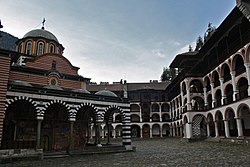
The Monastery of Saint Ivan of Rila, better known as the Rila Monastery (Bulgarian: Рилски манастир, Rilski manastir) is the largest and most famous Eastern Orthodox monastery in Bulgaria. It is situated in the southwestern Rila Mountains, 117 km (73 mi) south of the capital Sofia in the deep valley of the Rilska River at an elevation of 1,147 m (3,763 ft) above sea level. The monastery is named after its founder, the hermit Ivan of Rila (876 - 946 AD).

Founded in the 10th century, the Rila Monastery is regarded as one of Bulgaria's most important cultural, historical and architectural monuments and is a key tourist attraction for both Bulgaria and Southern Europe. In 2008 alone, it attracted 900,000 visitors. The monastery is depicted on the reverse of the 1 lev banknote, issued in 1999.

Wikipedia - Rila Monastery

Sunday, February 26, 2012

Budapest-Nyugati Railway Terminal


View Interesting Maps in a larger map

Budapest-Nyugati Railway Terminal
Budapest-Nyugati pályaudvar (Budapest-Western Railway Terminal) is one of the three main railway terminals of Budapest, Hungary. It lies at the intersection of Grand Boulevard and Váci Avenue.

The station was planned by August de Serres and was built by the Eiffel Company. It was opened on 28 October 1877. Previously another station stood in its place, the end station of Hungary's first railway line, the Pest–Vác line (constructed in 1846). This building was pulled down in order to construct the Nagykörút - Grand Boulevard which is now smaller than the outer ringroad (Hungária körút - Hungary Boulevard) and the recently opened motorway ringroad M0 (2008).

The station gave name to the immediately adjacent Nyugati tér (Western Square), a major intersection where Teréz körút (Theresia Boulevard), Szent István körút (Saint Stephen Boulevard), Váci út (Váci Avenue), and Bajcsy-Zsilinszky út (Bajcsy-Zsilinszky Avenue) converge. The square also serves as a transportation hub with several bus lines, tram 4 and 6, and a station of the M3 line of the Budapest Metro.

Hungarian State Railways runs regular service between the station and Budapest Ferihegy International Airport's Terminal 1. The trip takes approximately 25 minutes, costs 365 HUF, and runs 2-3 times per hour.

Beside the train station and partially above its open area there is the WestEnd City Center shopping mall.

Portions of the 2011 film Mission: Impossible – Ghost Protocol were filmed, and took place, in and around the station.

Wikipedia - Budapest-Nyugati Railway Terminal

Thursday, February 23, 2012

Navajo Bridge


View Interesting Maps in a larger map


Navajo Bridge crosses the Colorado River's Marble Canyon near Lee's Ferry in the US state of Arizona. Apart from the Glen Canyon Bridge a few miles upstream at Page, Arizona, it is the only roadway crossing of the river and the Grand Canyon for nearly 600 miles (970 km). Spanning Marble Canyon, the bridge carries northbound travelers to southern Utah and to the Arizona Strip, the otherwise inaccessible portion of Arizona north of the Colorado River, which includes the North Rim of Grand Canyon National Park.

Prior to the construction of the first Navajo Bridge, the only river crossing from Arizona to Utah was at nearby Lee's Ferry, where the canyon walls are low and getting vehicles onto the water is relatively convenient. The ferry offered only unreliable service, however, as adverse weather and flooding regularly prevented its operation.

Wikipedia - Navajo Bridge

Monday, February 20, 2012

Keukenhof - the Garden of Europe


View Interesting Maps in a larger map


Keukenhof ("Kitchen garden", Dutch pronunciation: [ˈkøːkə(n)ˌɦɔf]), also known as the Garden of Europe, is situated near Lisse, Netherlands, and is the world's largest flower garden. According to the official website for the Keukenhof Park, approximately 7,000,000 (seven million) flower bulbs are planted annually in the park, which covers an area of 32 hectares.

Keukenhof is located in South Holland in the small town of Lisse, south of Haarlem and southwest of Amsterdam. It is accessible by bus from the train stations of Haarlem, Leiden and Schiphol. It is located in an area called the "Dune and Bulb Region" (Duin- en Bollenstreek).

Keukenhof is open annually from the last week in March to mid-May. The best time to view the tulips is around mid-April, depending on the weather.

Wikipedia - Keukenhof

Saturday, February 18, 2012

Monte Corona


View Interesting Maps in a larger map


Monte Corona is a 609m high extinct volcano on the Canary Island of Lanzarote (Spain), near the village of Yé in the municipality of Haría. Its eruption around 4000 years ago covered a large area of the northeast of the island with lava, creating the Malpais de la Corona and two of the island's most-visited geological attractions, the Cueva de los Verdes and the Jameos del Agua.

Wikipedia - Monte Corona

Friday, February 10, 2012

Lake Vostok - Antarctica


View Interesting Maps in a larger map

Lake Vostok (Russian: озеро Восток, lit. "Lake East") is the largest of more than 140 subglacial lakes found under the surface of Antarctica. The overlying ice provides a continuous paleoclimatic record of 400,000 years, although the lake water itself may have been isolated for 15 to 25 million years.

Lake Vostok is located at the southern Pole of Cold, beneath Russia's Vostok Station under the surface of the central East Antarctic Ice Sheet, which is at 3,488 metres (11,444 ft) above mean sea level. The surface of this fresh water lake is approximately 4,000 m (13,100 ft) under the surface of the ice, which places it at approximately 500 m (1,600 ft) below sea level. Measuring 250 km (160 mi) long by 50 km (30 mi) wide at its widest point, and covering an area of 15,690 km2 (6,060 sq mi), it is similar in area to Lake Ontario, but with over three times the volume. The average depth is 344 m (1,129 ft). It has an estimated volume of 5,400 km3 (1,300 cu mi). The lake is divided into two deep basins by a ridge. The liquid water over the ridge is about 200 m (700 ft), compared to roughly 400 m (1,300 ft) deep in the northern basin and 800 m (2,600 ft) deep in the southern.

The lake is named after Vostok Station, which in turn is named after the Vostok, the 985-ton sloop-of-war sailed by one of the discoverers of Antarctica, Russian explorer Admiral Fabian von Bellingshausen. The word восток means "east" in Russian, and the name of the station and the lake also reflects the fact that they are located in East Antarctica. The lake was discovered and named by Russian geographer Andrey Kapitsa based on seismic soundings made during the Soviet Antarctic Expeditions in 1959 and 1964 to measure the thickness of the ice sheet. This was one of the last major geographic discoveries on Earth.

On 5 February 2012, a team of Russian scientists claimed to have completed the longest ever ice core of 3,768 m (12,400 ft) and pierced the ice shield to the surface of the lake. Samples of the freshly frozen water in the ice well are expected to be collected at the end of 2012 when the new Antarctic summer starts. The Russian team also plans to send a robot into the lake to collect water samples and sediments from the bottom. Unusual forms of life could be found in the lake's liquid layer, an ecosystem sealed off below the ice for millions of years, conditions which resemble those of the hypothesized ice-covered ocean of Jupiter's moon Europa.

Source: Wikipedia - Lake Vostok

Wednesday, February 8, 2012

Mole Antonelliana


View Interesting Maps in a larger map

Mole Antonelliana
The Mole Antonelliana is a major landmark of the Italian city of Turin. It is named for the architect who built it, Alessandro Antonelli. In Italian "Mole" (literally, "size") indicates a building of monumental proportions. Construction began in 1863, soon after Italian unification and was completed 26 years later, after the architect's death. Today it houses the National Museum of Cinema, and it is believed to be the tallest museum in the world.

Wikipedis - Mole Antonelliana

Sunday, January 29, 2012

Alhambra


View Interesting Maps in a larger map


The Alhambra ( /ælˈhæmbrə/; Spanish: [aˈlambɾa]; Arabic: الْحَمْرَاء‎, trans. al-Ḥamrā; literally "the red one"), the complete form of which was Calat Alhambra (Arabic: الْقَلْعَةُ ٱلْحَمْرَاءُ‎, trans. al-Qal‘at al-Ḥamrā’, "the red fortress"), is a palace and fortress complex located in the Granada, Andalusia, Spain. It was constructed during the mid 14th century by the Moorish rulers of the Emirate of Granada in al-Andalus, occupying the top of the hill of the Assabica on the southeastern border of the city of Granada.

~ Source: Wikipedia - Alhambra