View Interesting Maps in a larger map
The Musée des Plans-Reliefs is a museum of military models located within the Hôtel des Invalides in the 7th arrondissement of Paris, France. It is open daily except the first Monday of each month; an admission fee is charged.
The museum dates to 1668 when François-Michel le Tellier, Marquis de Louvois and minister of war to Louis XIV, began a collection of three-dimensional models of fortified cities for military purposes, known as 'plans-relief'. The models gave particular attention to the city fortifications and topographic features such as hills, harbors, etc. In 1700 Louis XIV installed the collection in the Louvre. Initially the models were constructed in the field, by military engineers, but in 1743 two central workshops were established for their construction in Béthune and Lille. A large number of models were built during and after the War of the Austrian Succession (1741-1748) to represent newly-captured sites. The collection was updated in 1754, but then fell into some disuse; the final models built under the Ancien Régime were those of Saint-Omer (1758) and the fort Saint-Philippe aux Baléares (1759).
In 1774 the collection was nearly destroyed when its Louvre gallery was rededicated to paintings, but was in 1777 moved to the Hôtel des Invalides where it remains to this day. Under Napoleon, a new set of models was built for new conquests, including Luxembourg (1802), La Spezia (1811), Brest (1811), and Cherbourg (1811-1813). Their production then continued until about 1870, when it drew to a close with the disappearance of fortifications bastionnées. The collection was declared a historical monument in 1927, and the museum established in 1943.
All told, some 260 plans-reliefs were created between 1668 and 1870, representing about 150 fortified sites. About 100 models are conserved today by this museum, of which about 15 are kept in the Musée des Beaux-Arts de Lille. At present, the museum displays 28 plans-reliefs of fortifications along the English Channel, the Atlantic and Mediterranean coasts, and the Pyrenees. It also contains presentations on construction and use of the plans-reliefs.
Source:
Wikipedia - Musée des Plans-Reliefs


 Fastnet Rock (from Old Norse: Hvasstann-ait meaning "sharp-tooth ait" — called in Irish: Carraig Aonair, meaning "solitary rock / lone rock") is a small clay-slate island with quartz veins and the most southerly point of Ireland, 6.5 km southwest of Cape Clear Island (Oileán Chléire) in County Cork, which is itself 13 km (8 miles) from the mainland. It lies in the Atlantic Ocean 11.3 km south of mainland County Cork, at latitude 51.37°N. It rises to about 30 m above low water mark.

 Frombork [ˈfrɔmbɔrk] (German: About this sound Frauenburg (help·info)) is a town in northern Poland, on the Vistula Lagoon, in Braniewo County, Warmian-Masurian Voivodeship. It had a population of 2,528 as of 2005.
 Samothrace (Greek: Σαμοθράκη, [samoˈθɾaci]) is a Greek island in the northern Aegean Sea. It is a self-governing deme within the Evros Prefecture of Thrace. The island is 17 km (11 mi) long and is 178 km2 (69 sq mi) in size and has a population of 2,723 (2001 census). Its main industries are fishing and tourism. Resources on the island includes granite and basalt. Samothrace is one of the most rugged Greek islands, with Mt. Fengari rising to 1,611 m.
 Walensee is one of the larger lakes in Switzerland, for about 2/3 of its surface in the Canton of St. Gallen and for 1/3 in the Canton of Glarus. It is also known as Lake Walen or Lake Walenstadt, after Walenstadt. Other towns and villages at the lake include: Weesen, Quinten, Quarten, and Murg.
 The Galleries of Justice is a museum of Crime and Punishment and tourist attraction on High Pavement in the Lace Market area of Nottingham, England.
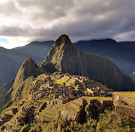 Machu Picchu (Quechua: Machu Pikchu) – "Old Mountain", pronounced [ˈmɑtʃu ˈpixtʃu]) – is a pre-Columbian Inca site located 2,430 metres (7,970 ft) above sea level.[1][2] It is situated on a mountain ridge above the Urubamba Valley in Peru, which is 80 kilometres (50 mi) northwest of Cuzco and through which the Urubamba River flows. Most archaeologists believe that Machu Picchu was built as an estate for the Inca emperor Pachacuti (1438–1472). Often referred to as "The Lost City of the Incas", it is perhaps the most familiar icon of the Inca World.
 The Thanet Wind Farm (also sometimes called Thanet Offshore Wind Farm) is an offshore wind farm 7 miles (11 km) off the coast of Thanet district in Kent, England. As of September 2010, it is the world's biggest offshore windfarm. It has a nameplate capacity of 300MW and it cost £800 million. Thanet is one of 15 Round 2 wind projects announced by the Crown Estate in January 2004. It was officially opened on 23 September 2010, when it overtook Horns Rev 2 as the biggest off-shore wind-farm in the world.
 The City of Arts and Sciences (Valencian: Ciutat de les Arts i les Ciències, Spanish: Ciudad de las Artes y las Ciencias) is an entertainment-based cultural and architectural complex in the city of Valencia, Spain. It is the most important modern tourist destination in the city of Valencia.
 Orlando Power Station is a decommissioned coal fired power station in Soweto, South Africa. The power station was commissioned at the end of the Second World War and served Johannesburg for over 50 years.
 Eureka Tower is a 297.3-metre (975 ft) skyscraper located in the Southbank precinct of Melbourne, Victoria, Australia. Construction began in August 2002 and the exterior completed on 1 June 2006. The plaza was finished in June 2006 and the building was officially opened on 11 October 2006. The project was designed by Melbourne architectural firm Fender Katsalidis Architects and was built by Grocon (Grollo Australia). The developer of the tower was Eureka Tower Pty Ltd, a joint venture consisting of Daniel Grollo (Grocon), investor Tab Fried and one of the Tower's architects Nonda Katsalidis. It was the world's tallest residential tower when measured to its highest floor, until surpassed by Ocean Heights and the HHHR Tower in Dubai. It is now the fourth-tallest, after Q1 located on Queensland's Gold Coast and the two Dubai skyscrapers.
 The Historic Centre (known in Brazilian Portuguese as The Pelourinho) is a historic neighborhood located in the western zone of Salvador, Bahia. It was the city's center during the Portuguese Colonial Period, and was named for the whipping post (Pelourinho means Pillory) in its central plaza where African slaves received punishment for various infractions, as well as for disciplinary purposes.
 Loftus Versfeld Stadium is a sports stadium situated in Pretoria, South Africa. The stadium has a capacity of 51,762 and is an all seater venue. Recently hosted the 2009 Currie Cup final.
 The Royal Bafokeng Sports Palace is an football, rugby and athletics stadium in Phokeng near Rustenburg, South Africa. It was built and is managed by the Royal Bafokeng Nation[1]. It is used as the home stadium for Premier Soccer League club Platinum Stars. The Leopards host large attendance matches during the Currie Cup at the stadium, instead of their usual home ground, Olen Park.
 The Peter Mokaba Stadium is a football stadium in Polokwane (formerly Pietersburg), South Africa, that will be used for the 2010 FIFA World Cup. When completed in 2010 it will have a capacity of 46,000.[1] It was named after Peter Mokaba, a former leader of the ANC Youth League. It is located 5 kilometers from the city centre and is located just east of the existing Pietersburg Stadium
 Mbombela Stadium is a newly built all seater 43,500-seat stadium and is one of the ten venues for the FIFA World Cup 2010. It is located on open land six kilometers west of Nelspruit, South Africa, with the stadium as the centrepiece of a proposed wider sports precinct with athletics and cricket as well as other sporting codes.
 Nelson Mandela Bay Stadium is a 48,000-seater stadium in Port Elizabeth.
 The Free State Stadium, also known as Vodacom Park, is a stadium in Bloemfontein, South Africa, used for rugby union, as well as football (soccer). It was originally built in 1995 for that year's Rugby World Cup.
 Ellis Park Stadium, also known because of its sponsorship by The Coca-Cola Company as Coca-Cola Park, is a rugby union and association football stadium in the city of Johannesburg, Gauteng Province, South Africa. It hosted the final of the 1995 Rugby World Cup, which was won by the country's national team, the Springboks. The large stadium was the country's most modern when it was upgraded in 1982 to accommodate almost 60,000 people. Today, the stadium hosts both football and rugby, and is also used as a venue for other large events, such as open-air concerts. It has become synonymous with rugby as the only time when rugby was not played at Ellis Park was during 1980 and 1981 when the stadium was under construction during an upgrade.
 The Moses Mabhida Stadium is a stadium in Durban, South Africa, named after Moses Mabhida, a former General Secretary of the South African Communist Party. It is intended to be a world-class multi-use stadium.
 The Green Point Stadium in Cape Town, South Africa was an 18,000 seat multi-purpose stadium.
 Soccer City, formerly known as the FNB Stadium, is a stadium located in the Soweto area of Johannesburg, South Africa. It is located next to the South African Football Association headquarters (SAFA House) where both the FIFA offices and the Local Organising Committee for the 2010 FIFA World Cup are housed.
 Positano is a small town and comune on the Amalfi Coast (Costiera Amalfitana), in Campania, Italy. The main part of the city sits in an enclave in the hills leading down to the coast.
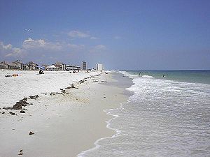 Pensacola Beach is an unincorporated community located on Santa Rosa Island, a barrier island, in Escambia County, Florida, United States. It is situated south of Pensacola, connected via bridges spanning to the Fairpoint Peninsula and then to the island, on the Gulf of Mexico. As of the 2000 census, the community had a total population of 2,738.
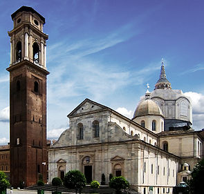 Turin Cathedral (Italian: Duomo di Torino) is the major Roman Catholic church of Turin, northern Italy. Dedicated to Saint John the Baptist (Italian: San Giovanni Battista), it was built during 1491-1498 and it is adjacent to an earlier campanile (1470). The Chapel of the Holy Shroud, the current resting place of the Shroud of Turin, was added to the structure in 1668-1694.
 The Metéora (Greek: Μετέωρα, "suspended rocks", "suspended in the air" or "in the heavens above") is one of the largest and most important complexes of Eastern Orthodox monasteries in Greece, second only to Mount Athos.[1] The six monasteries are built on natural sandstone rock pillars, at the northwestern edge of the Plain of Thessaly near the Pineios river and Pindus Mountains, in central Greece. The nearest town is Kalambaka. The Metéora is included on the UNESCO World Heritage List under criteria[2] I, II, IV, V and VII.[3]
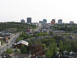 Yellowknife (pronounced /ˈjɛloʊnaɪf/) (2006 population: 18,700[1]) is the capital of the Northwest Territories (NWT), Canada. It is located on the north shore of Great Slave Lake, approximately 400 km (250 mi) south of the Arctic Circle, on the west side of Yellowknife Bay near the outlet of the Yellowknife River. Yellowknife and its surrounding water bodies were named after the local Yellowknives Dene First Nation, who made tools from regional copper deposits. The current population is ethnically mixed. Of the eleven official languages of the Northwest Territories, five are spoken in significant numbers in Yellowknife: Dene Suline, Dogrib, South and North Slavey, English, and French. In the Dogrib language, the city is known as Somba K'e ("where the money is").[2]
 Eyjafjallajökull (pronounced [ˈɛɪjaˌfjatlaˌjœkʏtl̥]) (About this sound listen (help·info)) is one of the smaller glaciers of Iceland. It is situated to the north of Skógar and to the west of the larger glacier Mýrdalsjökull.
 The Arsenal is a large trapezoid two-storey building in the northern corner of the Moscow Kremlin which currently accommodates the Kremlin Regiment.
 109 (Ichi-maru-kyū?) is a department store in Shibuya, Tokyo, Japan The store is operated by the Tokyu Malls Development (TMD), a company under the Tokyu Group.
 The Isle of Man (pronounced /ˈmæn/; Manx: Ellan Vannin, pronounced [ˈɛlʲən ˈvanɪn]), otherwise known simply as Mann (Manx: Mannin, [ˈmanɪn]), is a self-governing British Crown Dependency, located in the Irish Sea between the islands of Great Britain and Ireland. The head of state is Queen Elizabeth II, who holds the title of Lord of Mann. The Lord of Mann is represented by a Lieutenant Governor. The island is not part of the United Kingdom but its foreign relations, defence, and ultimate good governance are the responsibility of the Government of the United Kingdom.
 Windermere is the largest natural lake in England. It has been one of the country’s most popular places for holidays and summer homes since 1847, when the Kendal and Windermere Railway built a branch line to it. It is in the county of Cumbria and entirely within the Lake District National Park.
 The Dubai Mall is the world's largest shopping mall based on total area and sixth largest by gross leasable area. Located in Dubai, United Arab Emirates, it is part of the Burj Khalifa complex, the 20-billion-dollar project has 1,200 shops. Access to the mall is provided via Doha Street, rebuilt as a double-decker road in April 2009.
 The Church of St. George (Amharic: Bete Giyorgis?) is a monolithic church in Lalibela, Amhara Region, Ethiopia. It is the most well known and last built (early thirteenth century) of the eleven churches in the Lalibela area, and has been referred to as the "Eighth Wonder of the World". The dimensions of the complex are 25 meters by 25 meters by 30 meters, and there is a small baptismal pool outside the church, which stands in an artificial trench.
 Clos de Vougeot, also known as Clos Vougeot, is a wall-enclosed vineyard, a clos, in the Burgundy wine region, and an Appellation d'origine contrôlée (AOC) for red wine from this vineyard.[1] It was named for the River Vouge, which is in fact only a stream separating the village Vougeot from Chambolle-Musigny. At 50.6 hectares (125 acres),[2] Clos de Vougeot is the largest single vineyard in Côte de Nuits entitled to the grand cru designation, while Corton in Côte de Beaune is the largest grand cru in Burgundy as a whole.
 Burj Khalifa (Arabic: برج خليفة "Khalifa Tower"),[3] formerly known as Burj Dubai, is a skyscraper in Dubai, United Arab Emirates, and is the tallest man-made structure ever built, at 828 m (2,717 ft).[3] Construction began on 21 September 2004, with the exterior of the structure completed on 1 October 2009 and the building officially opened on 4 January 2010.[1][7] The building is part of the 2 km2 (490-acre) flagship development called Downtown Burj Khalifa at the "First Interchange" along Sheikh Zayed Road, near Dubai's main business district. The tower's architect and engineer is Skidmore, Owings and Merrill, LLP (Chicago).[8] Bill Baker, the Chief Structural Engineer for the project, invented the buttressed core structural system in order to enable the tower to achieve such heights economically. Adrian Smith, who worked with Skidmore, Owings and Merrill (SOM) until 2006, was the Design Partner on the project.[8][9]
 Bordeaux (in Gascon: Bordèu) is a port city on the Garonne River in southwest France, with one million inhabitants in its metropolitan area at a 2008 estimate. It is the capital of the Aquitaine region, as well as the prefecture of the Gironde department. Its inhabitants are called Bordelais.
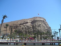 Arica is a commune and a port city with a population of 192,300 in the Arica and Parinacota Region in northern Chile, located only 18 km (11 miles) south of the border with Peru.


