Oahu (pronounced /oʊˈɑːhuː/ in English) or Oʻahu (pronounced /oˈʔɐhu/ in Hawaiian), known as "The Gathering Place", is the third largest of the Hawaiian Islands and most populous of the islands in the State of Hawaiʻi. The state capital Honolulu is located on the southeast coast. Including small close-in offshore islands such as Ford Island and the islands in Kaneohe Bay and off the eastern coast, it has a total land area of 596.7 square miles (1,545.4 km2), making it the 20th largest island in the United States.[2] It is also the most populous island in the Western Hemisphere that neither contains a national capital nor possesses a road or rail connection to a national capital. In greatest dimension, this volcanic island is 44 miles (71 km) long and 30 miles (48 km) across. The length of the shoreline is 227 miles (365 km). The island is the result of two separate shield volcanoes: Waiʻanae and Koʻolau, with a broad "valley" or saddle (the central Oʻahu Plain) between them. The highest point is Mt. Ka'ala in the Waiʻanae Range, rising to 4,003 feet (1,220 m) above sea level.[3]
Source: Wikipedia - Oahu
View Interesting Maps in a larger map
Wednesday, December 30, 2009
Sunday, December 20, 2009
Château Lafite Rothschild
View Interesting Maps in a larger map
 Château Lafite Rothschild is a wine estate in France, owned by members of the Rothschild banking family of France since the 19th century. The name Lafite comes from the Gascon term "la hite" meaning "small hill".
Only four wine-producing Châteaux of Bordeaux achieved First Growth status in the 1855 Classification, which was based on recent prices. Of those, the first one in the list is Château Lafite Rothschild, a consistent producer of one of the world's most expensive red wines.
Source: Château Lafite Rothschild - Wikipedia
Saturday, December 12, 2009
Long Street (Cape Town)
View Interesting Maps in a larger map
Long Street is a major street located in the City Bowl section of Cape Town, South Africa. It is famous as a bohemian hang out, as the street is lined by many bookstores, various ethnic restaurants and bars. Restaurants include African restaurants like Zula, and Indian restaurants like Masala Dosa. Long Street shows off a diversified culture and tourists from all over the world. It also has various backpackers hostels for youth from all over the world. Several theatres that showed anti-apartheid plays were located on the street during the 1970s and 1980s, although most have now closed in favour of restaurants or stores.
Source: Long Street (Cape Town) - Wikipedia
Thursday, December 10, 2009
Amalienborg Palace
View the large view of Interesting Maps
 Amalienborg Palace (Danish: Amalienborg, pronounced [aˈmaːˀliə̯nbɔːˀʀ]) is the winter home of the Danish royal family, and is located in Copenhagen, Denmark. It consists of four identical classicizing palace façades with rococo interiors around an octagonal courtyard (Amalienborg Slotsplads); in the center of the square is a monumental equestrian statue of Amalienborg's founder, King Frederik V.
Amalienborg was originally built for four noble families; however, when Christiansborg Palace burnt down on 26 February 1794, the royal family bought the palaces and moved in. Over the years various kings and their families have resided in the four different palaces.
Amalienborg Palace - Wikipedia
Tuesday, December 1, 2009
Mont Blanc
View Interesting Maps in a larger map
 Mont Blanc or Monte Bianco (French and Italian, respectively, meaning white mountain) is the highest mountain in the Alps and in Western Europe.[1] It rises 4,810 m (15,781 ft) above sea level and is ranked 11th in the world in topographic prominence. It is also sometimes known as "La Dame Blanche" (French, the white lady).
The mountain lies between the regions of Aosta Valley, Italy, and Haute-Savoie, France. The location of the summit is on the French-Italian border but French and Swiss cartographers place it within France's boundaries on maps. Lately, at the end of his studies of many different maps and with auxiliary of Istituto Cartografico dell’Esercito, Antonio Napolitano, the Italian leader of a mixed commission, claimed exclusive Italian ownership of the summit.[2][3]
The two most famous towns near Mont Blanc are Courmayeur, in Aosta Valley, Italy, and Chamonix, in Haute-Savoie, France — the site of the first Winter Olympics. A cable car ascends and crosses the mountain from Chamonix to Courmayeur.
Begun in 1957 and completed in 1965, the 11.6 km (7¼ mi) Mont Blanc Tunnel runs beneath the mountain between these two countries and is one of the major trans-Alpine transport routes.
The Mont Blanc Massif is popular for mountaineering, hiking, skiing and snowboarding.
Source: Mont Blanc - Wikipedia
Wednesday, November 25, 2009
Myrtle Beach
View Interesting Maps in a larger map
Myrtle Beach is a coastal resort city in Horry County, South Carolina, United States. It is the de facto hub of both the Myrtle Beach metropolitan area and the Grand Strand, a complex of beach towns and barrier islands stretching from Little River to Georgetown, South Carolina.
Arising from a getaway for lumber workers from Conway, Myrtle Beach has rapidly developed into a major tourist destination in the Southeastern United States in the latter 20th century and 2000s. As of 2006, the metro area had an estimated population of 299,353.[3] According to the 2000 census, the area was the 13th fastest-growing metropolitan area in the United States.
Source: Myrtle Beach, South Carolina - Wikipedia
Thursday, November 12, 2009
Mammoth Mountain
View Interesting Maps in a larger map
 Mammoth Mountain is a lava dome complex west of the town of Mammoth Lakes, California in the Inyo National Forest of Mono County.[3] It is home to a large ski area.
Mammoth Mountain was formed in a series of eruptions that ended 57,000 years ago. However, Mammoth still produces hazardous volcanic gases that kill trees and have caused ski patroller fatalities in 2006.
Source: Mammoth Mountain - Wikipedia
Tuesday, November 3, 2009
Marienplatz
View Interesting Maps in a larger map
 Marienplatz (en: Mary's Square, i.e. St. Mary, Our Lady's Square) is a central square in the city center of Munich, Germany since 1158.
In the Middle Ages markets and tournaments were held in this city square. Marienplatz was named after the Mariensäule, a Marian column erected in its centre in 1638 to celebrate the end of Swedish occupation. Today the Marienplatz is dominated by the New City Hall (Neues Rathaus) on the north side. The Glockenspiel in the tower of the new city hall was inspired by these tournaments, and draws millions of tourists a year. The New City Hall was built 1867 - 1909 in Flanders gothic style; its facade, over 300 feet in length, features strikingly elaborate stone ornamentation. Its 260-foot tower with carillon is, with the nearby St. Peter's Church and the twin towers of the Cathedral, one of the most distinctive features of the city's skyline." explains muenchen.de, which also ranks Marienplatz as one of the top ten sites in Munich. At the east side Munich's Old City Hall (Altes Rathaus) is located. It's a gothic council hall and ballroom and tower, which have been reconstructed.
The pedestrian zone between Karlsplatz and Marienplatz is a crowded area with numerous shops and restaurants.
The Marienplatz S-Bahn and U-Bahn station, an important transportation hub, is located below the square.
Source: Marienplatz - Wikipedia
Friday, October 30, 2009
Berlin Wall (German: Berliner Mauer)
View Interesting Maps in a larger map
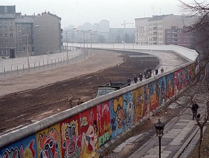 The Berlin Wall (German: Berliner Mauer) was erected by the German Democratic Republic (GDR) (East Germany) completely encircling West Berlin, separating it from East Germany, including East Berlin. The longer inner German border demarcated the border between East and West Germany. Both borders came to symbolize the Iron Curtain between Western Europe and the Eastern Bloc. Prior to the Wall's erection, 3.5 million East Germans had avoided Eastern Bloc emigration restrictions to escape into West Germany, many over the border between East and West Berlin. During its existence from 1961 to 1989, the Wall stopped almost all such emigration and separated East Germany from West Germany for more than a quarter of a century.[1] The Wall included guard towers lining large concrete walls circumscribing a wide area (later known as the "death strip") containing anti-vehicle trenches, "fakir beds" and other defenses. After its erection, around 5,000 people attempted to escape circumventing the wall, with estimates of the resulting death toll varying between 98 and 200.
During a revolutionary wave sweeping across the Eastern Bloc, the East German government announced on November 9, 1989, after several weeks of civil unrest, that all GDR citizens could visit West Germany and West Berlin. Crowds of East Germans climbed onto and crossed the wall, joined by West Germans on the other side in a celebratory atmosphere. Over the next few weeks, parts of the wall were chipped away by a euphoric public and by souvenir hunters; industrial equipment was later used to remove almost all of the rest. The fall of the Berlin Wall paved the way for German reunification, which was formally concluded on October 3, 1990.
Source: Berlin Wall - Wikipedia
Thursday, October 29, 2009
Karuizawa, Nagano
View Interesting Maps in a larger map
Karuizawa (軽井沢町, Karuizawa-machi?) is a town located in Kitasaku District, Nagano, Japan.
As of January 1, 2008, the town has an estimated population of 17,833 and has a total area of 156.05 square kilometres (60.25 sq mi).
Karuizawa is known throughout Japan as a popular tourist spot. People from Tokyo will travel to Karuizawa to get away from the city especially in summer. There is a Shinkansen station as well as a large outlet store shopping mall. It is also known for its historic shopping street known as "Ginza dōri" or "Kyū-dō" (Ginza Street, or the Old Road).
Karuizawa hosted equestrian events in the 1964 Summer Olympics. The town also hosted curling in the 1998 Winter Olympics. To date, it is the only city in the world having hosted both Summer and Winter Olympic events.
Source: Karuizawa, Nagano - Wikipedia
軽井沢周辺の滝/Waterfalls near Karuizawa(Shot on RED ONE)
Saturday, October 24, 2009
Bohol Island
View Interesting Maps in a larger map
Bohol Island is the main island of Bohol Province in the Visayas. It lies southeast from Cebu Island across Cebu Strait (in some references called Bohol Strait) and southwest from Leyte Island, separated by the Camotes Sea and Canigao Channel. Bohol is also located north of Mindanao with Bohol Sea between them.
With a land area of 3269 km² and a coastline 261 km long, Bohol is the tenth largest island of the Philippines. The main island is surrounded by about 70 smaller islands, the largest of which are Panglao Island facing Tagbilaran City in the southwest and Lapining Island in the northeast.
Source: Bohol (island) - Wikipedia
Rothenburg ob der Tauber
View Interesting Maps in a larger map
 Rothenburg ob der Tauber is a town in the district of Ansbach of Mittelfranken (Middle Franconia), the Franconia region of Bavaria, Germany, well known for its well-preserved medieval old town, a destination for tourists from around the world. In the Middle Ages, it was an Imperial Free City. A significant fraction of Rothenburg is car-free.
The name "Rothenburg ob der Tauber" means, in German, "Rothenburg above the Tauber". This is so because the town is located on a plateau overlooking the Tauber river. As to the name "Rothenburg", some say it comes from the German words Rot (Red) and Burg (burg, medieval fortified town), referring to the red colour of the roofs of the houses which overlook the river. The name may also refer to the process of retting ("rotten" in German) flax for linen production.
Since German does not have the th-sound (as in thin), the proper pronunciation of the first syllable of the name is more or less like English rote, while -burg is similar to "burk". In IPA (International Phonetic Alphabet): [ro:tənbʊag ɔp dєr taʊba].
Source: Rothenburg ob der Tauber - Wikipedia
Tuesday, October 20, 2009
Bamberg Cathedral
View Interesting Maps in a larger map
 The Bamberg Cathedral (German: Bamberger Dom, official name Bamberger Dom St. Peter und St. Georg) is one of the best-known architectural monuments in Germany and has been Bamberg’s most famous landmark since its completion in the 13th century. The cathedral is under the administration of the Roman Catholic Church and is the seat of the Archbishop of Bamberg.
The cathedral is a late Romanesque building with four imposing towers. It was founded in 1004 by the emperor Henry II, finished in 1012 and consecrated on May 6, 1012. It was later partially destroyed by fire in 1081. The new cathedral, built by St. Otto of Bamberg, was consecrated in 1111, and in the 13th century received its present late-Romanesque form.
The cathedral is about 94 m long, 28 m broad, 26 m high, and the four towers are each about 81 m high. Of its many works of art may be mentioned the magnificent marble tomb of the founder and his wife, the empress Cunigunde, considered the masterpiece of the sculptor Tilman Riemenschneider, and carved between 1499 and 1513.
Another treasure of the cathedral is an equestrian statue known as the Bamberg Horseman (German: Der Bamberger Reiter). This statue, possibly depicting the Hungarian king Stephen I., most likely dates approximately from 1225 to 1237.
Source: Bamberg Cathedral - Wikipedia
Monday, October 12, 2009
Cecilienhof
View Interesting Maps in a larger map
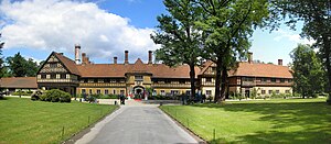 Schloss Cecilienhof is a palace in the northern part of the Neuer Garten park in Potsdam, close to the Jungfernsee lake. Since 1990 it is part of the Palaces and Parks of Potsdam and Berlin UNESCO World Heritage Site.
Cecilienhof was the last palace built by the Hohenzollern family. Emperor Wilhelm II of Germany had it erected for his son Crown Prince Wilhelm of Germany and the crown prince's wife Duchess Cecilie of Mecklenburg-Schwerin. The house was designed by Paul Schultze-Naumburg to look like an English Tudor country house [1] and built between 1914 and 1917. Its design was based on a house called 'Bidston Court' (later 'Hillbark') on the Wirral Peninsula.[2] which in turn was inspired by Little Moreton Hall.[3] The interior was furnished according to plans by Paul Troost, who originally had designed steamship décors.
The brick and oak timberframe building including 5 courtyards and 55 carved brick chimney tops should have been completed in 1915, nevertheless construction delayed due to the outbreak of World War I and Crown Prince Wilhelm and Cecilie could not move in until August 1917. Wilhelm followed his father into exile one year later, while Cecilie stayed at the palace until she fled from the approaching Red Army in February 1945.
Cecilienhof was the location of the Potsdam Conference between July 17 and August 2, 1945. Afore the rooms had been largely refurnished to match the taste of the participants. Winston Churchill, later Clement Attlee, Joseph Stalin and Harry S. Truman met at the round table in the great hall. On July 26, 1945 Churchill and Truman issued the Potsdam Declaration defining the terms for Japanese surrender, while Truman had already given order to prepare the atomic bombing of Hiroshima and Nagasaki.
Today Cecilienhof is a museum as well as a hotel. Queen Elizabeth II visited Cecilienhof on November 3, 2004. On May 30, 2007 the palace was used for the G8 foreign ministers summit.
Source: Cecilienhof - Wikipedia
Friday, October 9, 2009
Tübingen
View Interesting Maps in a larger map
 Tübingen, a traditional university town in Baden-Württemberg, Germany, is situated 30 km (19 miles) southwest of Stuttgart, on a ridge between the Neckar and Ammer rivers.
In central Tübingen, the Neckar river divides briefly into two streams, forming the elongated 1500 meter-long Neckarinsel (Neckar Island), famous for its Platanenallee with high plane trees, some of which are more than 200 years old. Pedestrians can reach the island via stairs on the narrow ends leading down from two bridges spanning the Neckar. During the summer, the Neckarinsel is occasionally the venue for concerts, plays and literary readings. The row of historical houses across one side of the elongated Neckarinsel is called the Neckarfront and includes the house with adjoining tower where poet Friedrich Hölderlin stayed for the last 36 years of his life as he struggled with mental instability.
View from the Stiftskirche.
Tübingen town hall.
Neckar and Hölderlinturm.
Stiftskirche.
Tübingen's Altstadt (old town) survived the Second World War due to the city's lack of heavy industry. The result is a growing domestic tourism business as visitors come to wander through one of the few completely intact historic Altstädte in Germany. The highlights of Tübingen include its crooked cobblestone lanes, narrow-stair alleyways picking their way through the hilly terrain, streets lined with canals and well-maintained traditional half-timbered houses.
Old town landmarks include the Rathaus (City Hall) on Marktplatz (Market Square) and the castle, Schloß Hohentübingen, now part of the University of Tübingen. The central landmark is the Stiftskirche (Collegiate Church). Along with the rest of the city, the Stiftskirche was one of the first to convert to Martin Luther's protestant church. As such, it maintains (and carefully defends) several "Roman Catholic" features, such as patron saints. Below the Rathaus is a quiet, residential street called the Judengasse, the former Jewish neighborhood of Tübingen until the town's Jews were expelled 1477. On the street corner is a plaque commemorating the fate of Tübingen's Jews.
The centre of Tübingen is the site of weekly and seasonal events, including regular market days on the Holzmarkt by the Stiftskirche and the Marktplatz by the Rathaus, an outdoor cinema in winter and summer, festive autumn and Christmas markets and Europe's largest Afro-Brazilian festival.
Students and tourists also come to the Neckar river in the summer to visit beer gardens or go boating in Stocherkähne, the Tübingen equivalent to Oxford and Cambridge punts, only slimmer. A Stocherkahn carries up to 20 people. On the second Thursday of June all Stocherkahn punts take part in a major race, the Stocherkahnrennen.
Source: Tübingen - Wikipedia
Friday, October 2, 2009
Sanssouci
View Interesting Maps in a larger map
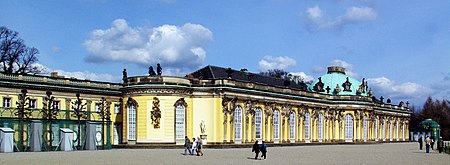 Sanssouci is the former summer palace of Frederick the Great, King of Prussia, in Potsdam, near Berlin. It is often counted among the German rivals of Versailles. While Sanssouci is in the more intimate Rococo style and is far smaller than its French Baroque counterpart, it too is notable for the numerous temples and follies in the park. The palace was designed by Georg Wenzeslaus von Knobelsdorff between 1745 and 1747 to fulfil King Frederick's need for a private residence where he could relax away from the pomp and ceremony of the Berlin court. This is emphasised by the palace's name: a French phrase (sans souci) which translates loosely as "without worries" or "carefree" symbolising that the palace was a place for relaxation rather than a seat of power. The palace is little more than a large single-storey villa—more like the Château de Marly than Versailles. Containing just ten principal rooms, it was built on the brow of a terraced hill at the centre of the park. The influence of King Frederick's personal taste in the design and decoration of the palace was so great that its style is characterised as "Frederician Rococo", and his feelings for the palace were so strong that he conceived it as "a place that would die with him".[1] Because of a disagreement about the site of the palace in the park, Knobelsdorff was fired in 1746. Jan Bouman, a Dutch architect, finished the project.
During the 19th century, the palace became a residence of Frederick William IV. He employed the architect Ludwig Persius to restore and enlarge the palace, while Ferdinand von Arnim was charged with improving the grounds and thus the view from the palace. The town of Potsdam, with its palaces, was a favourite place of residence for the German imperial family until the fall of the Hohenzollern dynasty in 1918.
Frederick the Great (1712–86).
After World War II, the palace became a tourist attraction in East Germany. It was fully maintained with due respect to its historical importance, and was open to the public. Following German reunification in 1990, the final wish of Frederick came to pass: his body was finally returned to his beloved palace and buried in a new tomb overlooking the gardens he had created. Sanssouci and its extensive gardens became a World Heritage Site in 1990 under the protection of UNESCO;[2] in 1995, the Foundation for Prussian Palaces and Gardens in Berlin-Brandenburg was established to care for Sanssouci and the other former imperial palaces in and around Berlin. These palaces are now visited by more than two million people a year from all over the world.
Source: Sanssouci - Wikipedia
Thursday, October 1, 2009
Rovos Rail
View Interesting Maps in a larger map
 Rovos Rail is a private railway company operating out of Capital Park Station in Pretoria, South Africa.
Rovos Rail runs cruise trains to a regular schedule on various routes throughout Southern Africa. The trains consist of beautifully restored South African coaches with all the usual tourist facilities - lounge, restaurant, private sleeping compartments and showers.
The company was started in 1989 by Rohan Vos.
Source: Rovos Rail - Wikipedia
Dresdner Frauenkirche
View Interesting Maps in a larger map
 The Dresdner Frauenkirche ("Church of Our Lady") is a Lutheran church in Dresden, Germany.
The Dresden Frauenkirche survived the firebombing of Dresden during World War II but was totally burned out and collapsed the next day. It has been reconstructed as a landmark symbol of reconciliation between former warring enemies. The reconstruction of its exterior was completed in 2004, its interior in 2005 and after 13 years of rebuilding, the church was reconsecrated on 30 October 2005 with festive services lasting through the Protestant observance of Reformation Day on 31 October.
Once a month, an Anglican Evensong in English is held in the Frauenkirche, with clergy sent from St. George's Anglican Chaplaincy in Berlin.
Source: Dresdner Frauenkirche - Wikipedia
Friday, September 25, 2009
Semperoper
View Interesting Maps in a larger map
 The Semperoper is the opera house of the Saxon State Opera Dresden (German: Sächsische Staatsoper Dresden) and the concert hall of the Sächsische Staatskapelle Dresden in Dresden, Germany. It was first built in 1841, by architect Gottfried Semper.
Source: Semperoper - Wikipedia
Zwinger
View Interesting Maps in a larger map
 The Zwinger Palace (Der Dresdner Zwinger) in Dresden is a major baroque German landmark.
The location was formerly part of the Dresden fortress of which the outer wall is conserved. The name derives from the German word Zwinger (outer ward of a concentric castle); it was for the cannons that were placed between the outer wall and the major wall. The Zwinger was not enclosed until the neoclassical building by Gottfried Semper called the Semper wing was built to host the Gemäldegalerie Alte Meister art gallery.
Source: Zwinger - Wikipedia
Thursday, September 24, 2009
Visa Black Card
The Black Card is unlike any other card and provides Cardmembers with these exclusive privileges:
|
San Diego Museum of Man
View Interesting Maps in a larger map
 The San Diego Museum of Man is a museum of anthropology located in Balboa Park, San Diego, California. The museum's collections and permanent exhibits focus on the pre-Columbian history of the western Americas, with materials drawn from Native American cultures of the Southern California region, Mesoamerican civilizations such as the Maya, and the Andean civilizations such as the Moche. The museum also holds a collection of Ancient Egyptian antiquities, and several others from around the world. Total holdings number over 72,000 artefacts across all collections, together with some 37,000 historical photographs, mainly of Native Americans.
Source: San Diego Museum of Man - Wikipedia
Sunday, September 20, 2009
Janitzio
View Interesting Maps in a larger map
 Isla de Janitzio is the main island of Lake Patzcuaro in the state of Michoacán, Mexico.
The town of Janitzio, which means "where it rains", is located atop the hill. Janitzio can only be reached by boats which run regularly back and forth from about 7:30 am to 6 pm, accessible from Pátzcuaro's pier (embarcadero). These boats can be hired to take you around other parts of the lake. The town is famous for the butterfly fishermen who are skilled at lowering their butterfly-shaped nets to catch the local famous cuisine "pescado blanco". The butterfly fisherman were also located on the back side of the 50 peso Mexican banknote.
Source: Janitzio - Wikipedia
Introduction
Set out on a tour of the colonial heritage sites of Mexico and get acquainted with its local tradition, quaint villages and colonial architecture. Enjoy a boat ride on the tranquil waters of Lake Patzcuaro to Janitzio Island and come face-to-face with the indigenous Purepecha tribes. At the market of Tlaquepaque, pick up armloads of souvenirs ranging from clay figures, blown glass, paper-mache, tin ware, and pottery.
Take a trip to Guanajuato, nestled in the hills of Sierra de Guanajuato and explore its ‘callejones’ or alleyways and the famous basilica and churches built by the wealth from its prosperous silver mines. Lose yourself further in colonial history at the charming city of San Miguel de Allende. This excursion allows you to explore Mexico from a new perspective.
Friday, September 18, 2009
Whitby Abbey
View Interesting Maps in a larger map
 Whitby Abbey is a ruined Benedictine abbey sited on the East Cliff, 199 steps above Whitby harbour in North Yorkshire on the north-east coast of England.
It was founded in 657 AD by the Anglo-Saxon King of Northumbria, Oswy (Oswiu) as Streoneshalh (the historical name of the town Whitby where the abbey is located).[1] He appointed Lady Hilda, abbess of Hartlepool Abbey and niece of Edwin the first Christian king of Northumbria, as founding Abbess. The name Streoneshalh is thought to signify Fort Bay or Tower Bay in reference to a supposed Roman settlement that previously existed on the site. This contention has never been proven though and alternate theories have been proposed, such as the name meaning Streona's settlement; a reference to Eadric Streona. This is highly unlikely though due to chronological considerations: Streona died in 1017 so the naming of Streoneshalh would have preceded his birth by several hundred years.[2]
The double monastery of Benedictine monks and nuns was also home to the great Saxon poet Caedmon. In 664, the abbey was the site of the Synod of Whitby, at which King Oswiu ruled that the Northumbrian Church would adopt the Roman calculation of Easter and monastic tonsure.
In 867, the abbey fell to Viking attack, and was abandoned.
William de Percy ordered that the abbey be refounded (1078) by Regenfrith (Reinferd) a soldier monk, dedicating it to St. Peter and St. Hilda. Later it became Presteby (meaning the habitation of Priests in Old Norse) then Hwytby; next Whiteby, (meaning the "white settlement" in Old Norse, probably from the colour of the houses) and finally Whitby.
The second monastery lasted until it was destroyed by Henry VIII in 1540 during the Dissolution of the Monasteries. The abbey buildings fell into ruins, and were mined for stone, but remained a prominent landmark for sailors and helped inspire Bram Stoker's Dracula.[citation needed] The ruins are now owned and maintained by English Heritage.
Source: Whitby Abbey - Wikipedia
Thursday, September 17, 2009
Griffith Observatory
View Interesting Maps in a larger map
 Griffith Observatory is located in Los Angeles, California, United States. Sitting on the south-facing slope of Mount Hollywood in L.A.'s Griffith Park, it commands a view of the Los Angeles Basin, including downtown Los Angeles to the southeast, Hollywood to the south, and the Pacific Ocean to the southwest. The observatory is a popular tourist attraction that features an extensive array of space- and science-related displays.
Griffith Observatory - Wikipedia
Friday, September 11, 2009
Glacier National Park (Canada)
View Interesting Maps in a larger map
Glacier National Park is one of seven national parks in British Columbia, and is part of a system of 43 parks and park reserves across Canada. It protects a portion of the Columbia Mountains. It also contains the Rogers Pass National Historic Centre, designated for its importance in the construction and development of Canada's first major national transportation route. It is 1,349 km² (521 mi²) in area and was established in 1886. It contains extensively glaciated areas.
Source: Glacier National Park (Canada) - Wikipedia
Glacier National Park (U.S.)
View Interesting Maps in a larger map
Glacier National Park is located in the U.S. state of Montana, bordering the Canadian provinces of Alberta and British Columbia to the North and the Blackfeet Indian Reservation to the East. Glacier National Park contains two mountain ranges, sometimes referred to as the southern extension of the Canadian Rockies mountain ranges, with over 130 named lakes, more than 1,100 different species of vascular plants and hundreds of species of animals. This vast pristine ecosystem, spread across 1,584 mi² (4,101 km²), is the centerpiece of what has been referred to as the "Crown of the Continent Ecosystem", a region of protected land encompassing 16,000 mi² (44,000 km²).[1] The famed Going-to-the-Sun Road, a National Historic Civil Engineering Landmark, traverses through the heart of the park and crosses the Continental Divide, allowing visitors breathtaking views of the rugged Lewis and Livingston mountain ranges, as well as dense forests, alpine tundra, waterfalls and two large lakes. Along with the Going-to-the-Sun Road, five historic hotels and chalets are listed as National Historic Landmarks, and a total of 350 locations are on the National Register of Historic Places.
Glacier National Park borders Waterton Lakes National Park in Canada—the two parks are known as the Waterton-Glacier International Peace Park, and were designated as the world's first International Peace Park in 1932. Both parks were designated by the United Nations as Biosphere Reserves in 1976, and in 1995 as World Heritage sites.[2] Glacier National Park also shares the northern boundary with the Akamina - Kishenena Provincial Park in British Columbia, Canada.
Source: Glacier National Park (U.S.) - Wikipedia
Sunday, September 6, 2009
Detian - Ban Gioc Falls
 Detian - Banyue Falls (Chinese: 德天瀑布 & 板約瀑布) or Ban Gioc Falls (Vietnamese: thác Bản Giốc),[Note 1] are 2 waterfalls on the Quy Xuan River straddling the Sino-Vietnamese border, located in in the Karst hills of Daxing County in the Chongzuo prefecture of Guangxi Province, on the Chinese side, and in the district of Trung Khanh, Cao Bằng province on the Vietnamese side, 272 km north of Hanoi.[Ref 1]
The waterfall falls thirty meters. It is separated into three falls by rocks and trees, and the thundering effect of the water hitting the cliffs can be heard from afar.[Ref 2]
It is currently the 4th largest waterfall along a national border after Iguazu Falls, Victoria Falls, and Niagara Falls.
Source: Detian - Ban Gioc Falls - Wikipedia
View Interesting Maps in a larger map
Saturday, September 5, 2009
Cathedral of Christ the Saviour
View Interesting Maps in a larger map
 The Cathedral of Christ the Saviour (Russian: Храм Христа Спасителя) or Hram hrista spasitelya is a Church in Moscow, Russia, on the bank of the Moskva River, a few blocks west of the Kremlin. It is the tallest Eastern Orthodox church.
Source: Cathedral of Christ the Saviour - Wikipedia
Pushkin Museum
View Interesting Maps in a larger map
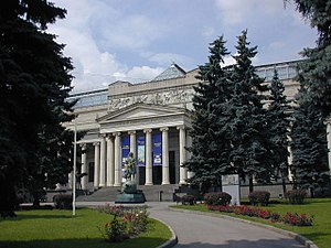 The Pushkin Museum of Fine Arts (Russian: Музей изобразительных искусств им. А.С. Пушкина) is the largest museum of European art in Moscow, located in Volkhonka street, just opposite the Cathedral of Christ the Saviour.
Source: Pushkin Museum - Wikipedia
Friday, September 4, 2009
Yueyaquan (月牙泉)
View Interesting Maps in a larger map
Yueyaquan (Chinese: 月牙泉; pinyin: Yuèyá Quán) is a crescent-shaped lake in the oasis, 5 km southwest of the city Dunhuang of Gansu province, China. It was named Yueyaquan since Qing Dynasty. According to measurement made in 1960, the average depth of the lake was 4 to 5 meters, with maximum depth 7.5 meters. In the following 40 years, the depth of lake continually declined. In the early 1990s, the area of the lake had shrunken to only 1.37-acre (5,500 m2) with average depth of 0.9 meter (maximum 1.3 meter). Although local government had plans to restore the depth through filling with water, the lack of budget has delayed their actions. The lake and the surrounding deserts are very popular with tourists, who are offered camel and 4x4 rides.
Crescent Lake (Dunhuang) - Wikipedia
USS Arizona Memorial
View Interesting Maps in a larger map
 The USS Arizona Memorial, located at Pearl Harbor in the City and County of Honolulu, Hawaiʻi, marks the resting place of 1,102 of the 1,177 sailors killed on the USS Arizona during the Attack on Pearl Harbor on December 7, 1941 by Japanese imperial forces and commemorates the events of that day. The attack on Pearl Harbor and the island of Oʻahu was the action that led to United States involvement in World War II.
The memorial, dedicated in 1962 and visited by more than one million people annually,[1] spans the sunken hull of the battleship without touching it. Since it opened in 1980, the National Park Service has operated the USS Arizona Memorial Visitor Center associated with the memorial. Historical information about the attack, boat access to the memorial, and general visitor services are available at the center. The sunken remains of the battleship were declared a National Historic Landmark on 5 May 1989.[2]
USS Arizona Memorial - Wikipedia
Meteor Crater
 Meteor Crater is a meteorite impact crater located approximately 43 miles (69 km) east of Flagstaff, near Winslow in the northern Arizona desert of the United States. Because the US Department of the Interior Division of Names commonly recognizes names of natural features derived from the nearest post office, the feature acquired the name of "Meteor Crater" from the nearby post office named Meteor[1]. The site was formerly known as the Canyon Diablo Crater, and scientists generally refer to it as Barringer Crater in honor of Daniel Barringer who was first to suggest that it was produced by meteorite impact. The crater is privately owned by the Barringer family via their Barringer Crater Company.[2]
The owners of the Crater proclaim it to be "the first proven, best-preserved meteorite crater on earth."[3]
Meteor Crater lies at an elevation of about 1,740 m (5709 ft) above sea level. It is about 1,200 m (4,000 ft) in diameter, some 170 m deep (570 ft), and is surrounded by a rim that rises 45 m (150 ft) above the surrounding plains. The center of the crater is filled with 210-240 m (700-800 ft) of rubble lying above crater bedrock.[4] One of the interesting features of the crater is its squared-off outline, believed to be caused by pre-existing regional jointing (cracks) in the strata at the impact site.[5]
Source: Wikipedia
View Interesting Maps in a larger map
Thursday, September 3, 2009
Crater Lake
View Interesting Maps in a larger map
 Crater Lake is a caldera lake located in the U.S. state of Oregon. It is the main feature of Crater Lake National Park and famous for its deep blue color and water clarity. The lake partly fills a nearly 1,958 foot (597 m) deep caldera[1] that was formed around 7,700 (± 150) BC[2] by the collapse of the volcano Mount Mazama.
On June 12, 1853, John Wesley Hillman was reportedly the first European American to see what he named "Deep Blue Lake" in Oregon. The lake was renamed at least three times, as Blue Lake, Lake Majesty, and finally Crater Lake.[3][4]
Crater Lake is known for the "Old Man of the Lake", a full-sized tree that has been bobbing vertically in the lake for more than a century.[5] Due to the cold water, the tree has been rather well preserved.
While having no indigenous fish population, the lake was stocked from 1888 to 1941 with a variety of fish. Several species have formed self sustaining populations.[6]
The commemorative Oregon State Quarter, which was released by the United States Mint in 2005, features an image of Crater Lake on its obverse.
Crater Lake - Wikipedia
Wednesday, September 2, 2009
Auschwitz concentration camp
View Interesting Maps in a larger map
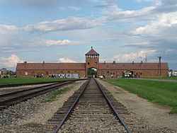 Auschwitz-Birkenau was the largest of Nazi Germany's concentration camps and extermination camps, operational during World War II.
The camp took its German name from the hosting town of Oświęcim. Following the German invasion of Poland in September 1939, Oświęcim was annexed by Nazi Germany and renamed Auschwitz, the town's German name.[1] Birkenau, the German translation of Brzezinka (birch tree), refers to a small Polish village nearby which later was mostly destroyed by the Germans.
Auschwitz concentration camp - Wikipedia
Sunday, August 30, 2009
National Gallery of Scotland
View Interesting Maps in a larger map
The National Gallery of Scotland, in Edinburgh, is the national art gallery of Scotland. An elaborate neoclassical edifice, it stands on The Mound, between the two sections of Edinburgh's Princes Street Gardens. The building, which was designed by William Henry Playfair, first opened to the public in 1859.
National Gallery of Scotland - Wikipedia
Thursday, August 27, 2009
Rhine Falls
View Interesting Maps in a larger map
View Larger Map
 The Rhine Falls (Rheinfall in German) are the largest plain waterfalls in Europe.[1]
The falls are located on the High Rhine between the municipalities of Neuhausen am Rheinfall and Laufen-Uhwiesen, near the town of Schaffhausen in northern Switzerland, between the cantons of Schaffhausen and Zürich. They are 150 m (450 ft) wide and 23 m (75 ft) high. In the winter months, the average water flow is 250 m³/s, while in the summer, the average water flow is 700 m³/s. The highest flow ehttp://www.blogger.com/img/blank.gifver measured was 1,250 m³/s in 1965; and the lowest, 95 m³/s in 1921.
Rhine Falls - Wikipedia
Tips to experience the REAL Europe, with Rail Europe
Fall in love with the Rhine Falls
Not exactly Niagara Falls, but just as beautiful and breathtaking! The Rhine Falls are a great excursion from Schaffhausen, a city not too far from Zurich. While the Rhine Falls are not known for their height, their width is spectacular. And on a sunny day, the spray from the falls create colorful rainbows. Schaffhausen can be reached from Zurich fairly easily. Travelers can hop on the train to Schaffhausen (approximately 45 minutes). From there, they can walk along the river to Neuhausen (approximately 45 minutes) or take the #1 or #6 bus from Schaffhausen to Neuhausen. From Neuhausen, the Rhine Falls are just a five minute walk - just follow the signs posted along the route. In all, it will take roughly 2 hours.
Friday, August 21, 2009
Olavinlinna
View Interesting Maps in a larger map
 Olavinlinna (Swedish: Olofsborg; literally St. Olaf's Castle, see Olaf II of Norway) is a 15th century three-tower castle located in Savonlinna, Finland. It is the world's most northern medieval stone fortress still standing.
Olavinlinna - Wikipedia
Kultaranta
View Interesting Maps in a larger map
The Kultaranta (Swedish Gullranda; "Golden beach") is the summer residence of the President of Finland. It is located in the district of Kultaranta on the island of Luonnonmaa, in Naantali. The granite manor house is surrounded by 560,000 square metres of park, belonging to the property.
Kultaranta's original owner was the businessman Alfred Kordelin, who had a manor house built for himself in 1914. It was designed by the famous architect Lars Sonck. When Kordelin died in 1917, the manor's ownership shifted to the University of Turku, and in 1922 the Finnish Parliament voted to acquire it for use as the president's summer residence.
The parks around the manor, containing approximately a thousand square metres of greenhouse and a garden with 3500 roses called Medaljonki ('medallion'), are open to the public. Tours in the garden are organised by the City of Naantali's tourist service.
Kultaranta - Wikipedia
Seurasaari
View Interesting Maps in a larger map
Seurasaari (Swedish Fölisön) is an island and a district in Helsinki, Finland, known mostly as the location of the Seurasaari Open-Air Museum, which consists of old, mainly wooden buildings transplanted from elsewhere in Finland and placed in the dense forest landscape of the island.
Every summer, many Helsinkians come to Seurasaari to enjoy the rural, peaceful outdoor atmosphere. Despite the visitors, the island has a variety of wildlife, especially birds, but also red squirrels and hares. The height of the island's popularity is at Midsummer, when a huge bonfire (Finnish "juhannuskokko") is built on a small isle just off the island's coast, and ignited by a newly-wed couple. Thousands of people, both tourists and Helsinkians, watch the burning of the bonfire from both Seurasaari itself and from boats anchored near it.
Seurasaari also includes one of only two nudist beaches in Helsinki and one of only three in the entire country. Unlike the other nudist beaches, the beach is segregated for men and women separately with no unisex nudist area.
Seurasaari - Wikipedia
Saturday, August 15, 2009
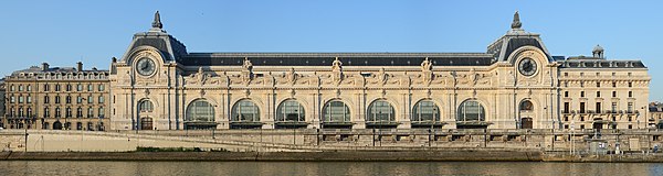
Musée d'Orsay
View Interesting Maps in a larger map
The Musée d'Orsay is a museum in Paris, France, on the left bank of the Seine, housed in the former railway station, the Gare d'Orsay, an impressive Beaux-Arts edifice built between 1898 and 1900. It holds mainly French art dating from 1848 to 1915, including paintings, sculptures, furniture, and photography, and is probably best known for its extensive collection of impressionist masterpieces by such painters such as Monet, Degas, Renoir, and Cezanne. Many of these works were held at the Galerie nationale du Jeu de Paume prior to the museum's opening in 1986.
Musée d'Orsay - Wikipedia
Friday, August 14, 2009
Kiyomizu-dera (清水寺)
View Interesting Maps in a larger map

Kiyomizu-dera (清水寺?), full name Otowa-san Kiyomizu-dera (音羽山清水寺?) is an independent Buddhist temple in eastern Kyoto. The temple is part of the Historic Monuments of Ancient Kyoto (Kyoto, Uji and Otsu Cities) UNESCO World Heritage site.[1] Not one nail is used in the whole temple. The temple should not be confused with Kiyomizu-dera in Yasugi, Shimane, which is part of the 33-temple route of the Chūgoku 33 Kannon Pilgrimage through western Japan.[2]
Kiyomizu-dera - Wikipedia
Thursday, August 13, 2009
Hirosaki Castle (弘前城, Hirosaki-jō)
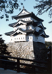 Hirosaki Castle (弘前城, Hirosaki-jō) is a 17th century Japanese castle located in Hirosaki city, Aomori prefecture, Japan. It was constructed in 1611 by the local Tsugaru clan. A three-storied castle tower, fortified moats, castle gates and some corner turrets (yagura) survive or have been reconstructed.
The surrounding Hirosaki Park is one of Japan's most famous cherry blossom spots. Over a million people enjoy the park's 2600 trees during the sakura matsuri (cherry blossom festival) when the cherry blossoms are in bloom, usually during the Japanese Golden Week holidays in the end of April and beginning of May.
Hirosaki Castle - Wikipedia
View Interesting Maps in a larger map
Jena, Home of Zeiss
View Interesting Maps in a larger map
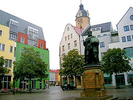 Jena (German pronunciation: [ˈjeːna]) is a university city in central Germany on the river Saale. With a population of 103,000 it is the second largest city in the federal state of Thuringia, after Erfurt.
At the end of the 19th century, with the building of the railway-line Saalbahn (along the river Saale) from Halle/Leipzig to Nürnberg, Jena became a center for precision machinery, optics and glass making, with the formation of the world famous companies Carl Zeiss Jena and Schott Jenaer Glaswerk, by Carl Zeiss, Ernst Abbe and Otto Schott.
Today Jena is a manufacturing city, specializing in precision machinery, pharmaceuticals, optics and photographic equipment, and is home to the famous Zeiss optics plant. In 1926, the world's first modern planetarium was built by the Zeiss company in the Damenviertel district of the town.
Jena - Wikipedia
Sunday, August 9, 2009
São Paulo (Saint Paul, Brazil)
View Interesting Maps in a larger map
São Paulo ([sɐ̃w ˈpawlu] is the largest city in Brazil, and is the world's 7th largest metropolitan area.[2][3] The city is the capital of the state of São Paulo, the most populous Brazilian state. It is also the richest city of Brazil. The name means Saint Paul in Portuguese. São Paulo exerts strong regional influence in commerce and finance as well as arts and entertainment.
São Paulo - Wikipedia
Saturday, August 8, 2009
Clevedon Pier
View Interesting Maps in a larger map
Clevedon Pier is a seaside pier in the town of Clevedon, on the English side of the mouth of the River Severn and the Bristol Channel. It is situated next to the Royal Pier Hotel.
The landing stage at the end of the pier is occasionally used by ships, notably the Waverley and her sister ship, the Balmoral, and is a popular spot for angling. There is a cafe at the pierhead, and a souvenir shop at the toll house. The upper floor of the toll house is occasionally used for art exhibitions. The pier is open every day of the year except Christmas Day.
Source: Clevedon Pier - Wikipedia
Perito Moreno Glacier
View Interesting Maps in a larger map
The Perito Moreno Glacier is a glacier located in the Los Glaciares National Park in the south west of Santa Cruz province, Argentina. It is one of the most important tourist attractions in the Argentine Patagonia.
The 250 km2 (97 sq mi) ice formation, and 30 km (19 mi) in length, is one of 48 glaciers fed by the Southern Patagonian Ice Field located in the Andes system shared with Chile. This icefield is the world's third largest reserve of fresh water.
More details: Perito Moreno Glacier - Wikipedia

Friday, August 7, 2009
Lichfield Cathedral
View Interesting Maps in a larger map
Lichfield Cathedral is situated in Lichfield, Staffordshire, England. It is the only medieval English cathedral with three spires. The Diocese of Lichfield covers all of Staffordshire, much of Shropshire and part of the Black Country and West Midlands. The present bishop is the Right Reverend Jonathan Gledhill, the 98th Lord Bishop of Lichfield.
Lichfield Cathedral - Wikipedia
Monday, August 3, 2009
Uffington White Horse
View Interesting Maps in a larger map
The Uffington White Horse is a highly stylised prehistoric hill figure, 374 feet (110 m) long, formed from deep trenches filled with crushed white chalk. The figure occurs on the upper slopes of White Horse Hill in the English civil parish of Uffington (in the county of Oxfordshire, historically Berkshire), some five miles south of the town of Faringdon and a similar distance west of the town of Wantage. The hill forms a part of the scarp of the Berkshire Downs and overlooks to Vale of White Horse to the north. Best views of the horse are obtained from the air, or from directly across the Vale, particularly around the villages of Great Coxwell, Longcot and Fernham. The site is owned and managed by the National Trust.
Info from Uffington White Horse - Wikipedia
Atacama Giant
View Interesting Maps in a larger map
 The Atacama Giant (Spanish: Gigante de Atacama) is a large anthropomorphic geoglyph in the Atacama Desert, Chile. Located at "Cerro Unitas", this is the largest prehistoric anthropomorphic figure in the world with a height of 86 meters and represents a deity for the local inhabitants from 1000 to 1400 AD.
from: Atacama Giant - Wikipedia
Friday, July 24, 2009
Mykonos
View Interesting Maps in a larger map
Mykonos (Greek: Μύκονος) is a Greek island and a tourist destination, renowned for its cosmopolitan character and its intense nightlife. The island is part of the Cyclades, lying between Tinos, Siros, Paros and Naxos. It spans an area of 105.183 km2 (41 sq mi) and rises at an elevation of 341 m (1,119 ft) at its highest point. The island is composed primarily of granite. It has little natural fresh water and relies on the desalination of sea water in order to meet its needs. There are 9,320 inhabitants (2001) most of whom live in the largest town, Mykonos, also known as Chora (i.e. the Town in Greek, a common denomination in Greece when the name of the island itself is the same as the name of the principal town), which lies on the west coast.
from: Mykonos - Wikipedia
Santorini
View Interesting Maps in a larger map
Santorini (Greek: Σαντορίνη, pronounced [ˌsa(n)do̞ˈrini]) is a small, circular archipelago of volcanic islands located in the southern Aegean Sea, about 200 km southeast from Greece's mainland. It is also known as Thera (or Thira, Greek Θήρα [ˈθira]), forming the southernmost member of the Cyclades group of islands, with an area of approximately 73 km² (28 mi²) and a 2001 census population of 13,670. It is composed of the Municipality of Thira (pop. 12,440) and the Community of Oía (Οία, pop. 1,230, which includes 268 inhabitants resident on the offshore island of Therasia, lying to the west). These have a total land area of 90.623 km², which also includes the uninhabited islands of Nea Kameni, Palaia Kameni, Aspronisi, and Christiana (all part of the Municipality of Thira).
from: Santorini - Wikipedia
Tuesday, July 21, 2009
Melrose Avenue
View Interesting Maps in a larger map
 Melrose Avenue is a well-known Los Angeles street that starts from Santa Monica Boulevard at the border between Beverly Hills and West Hollywood and ends at Hoover Street in Silver Lake. Melrose runs north of Beverly Boulevard and south of Santa Monica Boulevard.
Melrose is also useful as an east-west thoroughfare since it is usually at least four lanes in width, and left turns are prohibited during rush hour.
from: Melrose Avenue - Wikipedia
Sunday, July 19, 2009
Forth Railway Bridge
View Interesting Maps in a larger map
 The Forth Bridge is a cantilever railway bridge over the Firth of Forth in the east of Scotland, to the east of the Forth Road Bridge, and 14 km (9 miles) west of central Edinburgh. It is often called the Forth Rail Bridge or Forth Railway Bridge to distinguish it from the Forth Road Bridge, but should correctly be referred to as the Forth Bridge.[citation needed] The bridge connects Scotland's capital Edinburgh with Fife, and acts as a major artery connecting the north-east and south-east of the country. Described as "the one internationally recognised Scottish landmark",[1] it may be nominated by the British government as a UNESCO World Heritage Site.[2] The bridge and its associated railway infrastructure is owned by Network Rail Infrastructure Limited.
from Forth Railway Bridge - Wikipedia
Subscribe to:
Posts (Atom)


