View Interesting Maps in a larger map
York Castle in the city of York, England, is a fortified complex comprising, over the last nine centuries, a sequence of castles, prisons, law courts and other buildings on the south side of the River Foss. The now-ruinous keep of the medieval Norman castle is sometimes referred to as Clifford's Tower. Built originally on the orders of William I to dominate the former Viking city of York, the castle suffered a tumultuous early history before developing into a major fortification with extensive water defences. After a major explosion in 1684 rendered the remaining military defences uninhabitable, York Castle continued to be used as a jail and prison until 1929.
The first motte and bailey castle on the site was built in 1068 following the Norman conquest of York. After the destruction of the castle by rebels and a Viking army in 1069, York Castle was rebuilt and reinforced with extensive water defences, including a moat and an artificial lake. York Castle formed an important royal fortification in the north of England.
In 1190, 150 local Jews were killed in a pogrom in the castle keep. Henry III rebuilt the castle in stone in the middle of the 13th century, creating a keep with a unique quatrefoil design, supported by an outer bailey wall and a substantial gatehouse. During the Scottish wars between 1298 and 1338, York Castle was frequently used as the centre of royal administration across England, as well as an important military base of operations.
York Castle fell into disrepair by the 15th and 16th centuries, becoming used increasingly as a jail for both local felons and political prisoners. By the time of Elizabeth I the castle was estimated to have lost all of its military value but was maintained as a centre of royal authority in York. The outbreak of the English Civil War in 1642 saw York Castle being repaired and refortified, playing a part in the Royalist defence of York in 1644 against Parliamentary forces. York Castle continued to be garrisoned until 1684, when an explosion destroyed the interior of Clifford's Tower. The castle bailey was redeveloped in a neoclassical style in the 18th century as a centre for county administration in Yorkshire, and was used as a jail and debtors' prison. Prison reform in the 19th century led to the creation of a new prison built in a Tudor Gothic style on the castle site in 1825; used first as a county and then as a military prison, this facility was demolished in 1935. By the 20th century the ruin of Clifford's Tower had become a well-known tourist destination and national monument; today the site is owned by English Heritage and open to the public. The other remaining buildings serve as the York Castle Museum and the Crown Court.
Wikipedia - York Castle


 York Castle Museum is a museum located in York, North Yorkshire, England, on the site of York Castle, originally built by William the Conqueror in 1068. The museum itself was founded by Dr John L Kirk in 1938, and is housed in prison buildings which were built on the site of the castle in the 18th century, the Debtors Prison (built in 1701-05 using stone from the ruins of the castle) and the Female Prison (built 1780-1785).
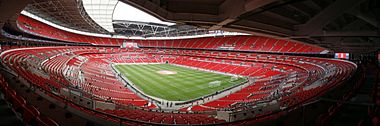 Wembley Stadium (often referred to simply as Wembley, pronounced /ˈwɛmbli/, or sometimes as the New Wembley) is a football stadium located in Wembley Park, in the Borough of Brent, London, England. It opened in 2007 and was built on the site of the previous 1923 Wembley Stadium. The earlier Wembley stadium, originally called the Empire Stadium, was often referred to as "The Twin Towers" and was one of the world's most famous football stadiums until its demolition in 2003.
 Castlefield is an inner city area of Manchester, in North West England. The conservation area which bears its name is bounded by the River Irwell, Quay Street, Deansgate and the Chester Road. It was the site of the Roman era fort of Mamucium or Mancunium which gave its name to Manchester. It was the terminus of the Bridgewater Canal, the world's first industrial canal built in 1764, with the oldest canal warehouse opening in 1779. The world's first passenger railway terminated here in 1830, at Liverpool Road railway station and the first railway warehouse opened here in 1831.

 The Galleries of Justice is a museum of Crime and Punishment and tourist attraction on High Pavement in the Lace Market area of Nottingham, England.
 The Thanet Wind Farm (also sometimes called Thanet Offshore Wind Farm) is an offshore wind farm 7 miles (11 km) off the coast of Thanet district in Kent, England. As of September 2010, it is the world's biggest offshore windfarm. It has a nameplate capacity of 300MW and it cost £800 million. Thanet is one of 15 Round 2 wind projects announced by the Crown Estate in January 2004. It was officially opened on 23 September 2010, when it overtook Horns Rev 2 as the biggest off-shore wind-farm in the world.
 The Isle of Man (pronounced /ˈmæn/; Manx: Ellan Vannin, pronounced [ˈɛlʲən ˈvanɪn]), otherwise known simply as Mann (Manx: Mannin, [ˈmanɪn]), is a self-governing British Crown Dependency, located in the Irish Sea between the islands of Great Britain and Ireland. The head of state is Queen Elizabeth II, who holds the title of Lord of Mann. The Lord of Mann is represented by a Lieutenant Governor. The island is not part of the United Kingdom but its foreign relations, defence, and ultimate good governance are the responsibility of the Government of the United Kingdom.
 Windermere is the largest natural lake in England. It has been one of the country’s most popular places for holidays and summer homes since 1847, when the Kendal and Windermere Railway built a branch line to it. It is in the county of Cumbria and entirely within the Lake District National Park.
 Whitby Abbey is a ruined Benedictine abbey sited on the East Cliff, 199 steps above Whitby harbour in North Yorkshire on the north-east coast of England.