View Interesting Maps in a larger map
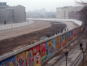 The Berlin Wall (German: Berliner Mauer) was erected by the German Democratic Republic (GDR) (East Germany) completely encircling West Berlin, separating it from East Germany, including East Berlin. The longer inner German border demarcated the border between East and West Germany. Both borders came to symbolize the Iron Curtain between Western Europe and the Eastern Bloc. Prior to the Wall's erection, 3.5 million East Germans had avoided Eastern Bloc emigration restrictions to escape into West Germany, many over the border between East and West Berlin. During its existence from 1961 to 1989, the Wall stopped almost all such emigration and separated East Germany from West Germany for more than a quarter of a century.[1] The Wall included guard towers lining large concrete walls circumscribing a wide area (later known as the "death strip") containing anti-vehicle trenches, "fakir beds" and other defenses. After its erection, around 5,000 people attempted to escape circumventing the wall, with estimates of the resulting death toll varying between 98 and 200.
During a revolutionary wave sweeping across the Eastern Bloc, the East German government announced on November 9, 1989, after several weeks of civil unrest, that all GDR citizens could visit West Germany and West Berlin. Crowds of East Germans climbed onto and crossed the wall, joined by West Germans on the other side in a celebratory atmosphere. Over the next few weeks, parts of the wall were chipped away by a euphoric public and by souvenir hunters; industrial equipment was later used to remove almost all of the rest. The fall of the Berlin Wall paved the way for German reunification, which was formally concluded on October 3, 1990.
Source: Berlin Wall - Wikipedia


