View Interesting Maps in a larger map
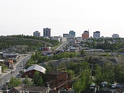
 Yellowknife (pronounced /ˈjɛloʊnaɪf/) (2006 population: 18,700[1]) is the capital of the Northwest Territories (NWT), Canada. It is located on the north shore of Great Slave Lake, approximately 400 km (250 mi) south of the Arctic Circle, on the west side of Yellowknife Bay near the outlet of the Yellowknife River. Yellowknife and its surrounding water bodies were named after the local Yellowknives Dene First Nation, who made tools from regional copper deposits. The current population is ethnically mixed. Of the eleven official languages of the Northwest Territories, five are spoken in significant numbers in Yellowknife: Dene Suline, Dogrib, South and North Slavey, English, and French. In the Dogrib language, the city is known as Somba K'e ("where the money is").[2]
Yellowknife was first settled in 1935, after gold had been found in the area; Yellowknife soon became the centre of economic activity in the NWT, and became the capital of the Northwest Territories in 1967. As gold production began to wane, Yellowknife shifted from being a mining town to being a centre of government services in the 1980s. However, with the discovery of diamonds north of Yellowknife in 1991,[3] this shift has begun to reverse.
Tourism is the largest renewable industry in the NWT and Yellowknife is the main entry point for visitors. Many of these tourists are Japanese, and come to experience the Northern climate and traditional lifestyle, as well as to see the Northern Lights. In 2004-05, visitors to the territory spent C$100.5 million.
Source: Wikipedia - Yellowknife


